Via Fernie Ridge’s southwest slopes. A strange Fernie ski tour, made stranger by the sounds of gunshots from a nearby shooting range, cornice collapses, wind-hammered terrain, and plans to develop the area into a ski resort and pedestrian community sharing the name of a suicidal UFO cult from the 70’s.
Parking

We parked at the base of the “Bear Chutes” mountain bike trail, up Ridgemont Road from Coal Creek Road. You can also approach from town via the “Sidewinder” mountain bike trails if you do not have a 4×4.
Trip Report

Our route begins up the “Bear Chutes” mountain bike trail on the left of the above picture. Luckily, we had a plowed pull-out at the bottom of the trail that we could park at.

Follow “Bear Chutes” for ~1.5km. Easy skinning up, but a sketchy, breakable-crust descent down this trail!

After about 1.5km, you will come across a logging road. Turn right and head up the large cutblock shown above. This will bring you to the start of Heaven’s Gate hiking/mountain biking trail which leads up to the ridge.

Once at the cutblock, keep climber’s right until you find an opening at the top of the block, marking the start of the hiking/biking trail.

Follow the trail until you break out into a clearing. The ascent route continues along the hiking/biking trail, zig-zagging through the trees until you reach the ridge.There is good descent down the drainage on the looker’s left of the above picture.

Bootpacking up the icy and wind hammered slopes to gain the ridge. Note that there are some significant cornices that line this ridge, shown on the right of the above picture. A fellow from the group ahead of us actually broke through the cornice when trying to scope a line down the aforementioned drainage LOL. Thankfully, he was OK!

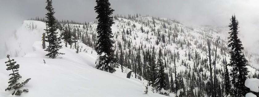
Looking back while skinning up the ridge. Cool views through the clouds.
Looking ahead towards south-facing slopes of Heaven’s Gate. Cornices and faceted slopes were too much of a concern for us to safely proceed to the top, but you could probably get a couple short runs down these slopes if you wanted. The slopes were pretty wind-hammered, though.

On the way down, we followed some ski tracks which led safely into the drainage below the ridge, shown above at location 49.5118N 114.9988W. Ski quality wasn’t bad down here! You could enter the drainage from higher up if you want.
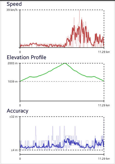
Stats

GPS route shown above in blue. You can see our track entering the drainage at approximately 6000 feet (the northerly track is our descent).

Times and distances round trip.